When The Waters Recede: Walking to Batu Ferringhi Isle
By Rexy Prakash Chacko
May 2025 PEAKS AND PARKS
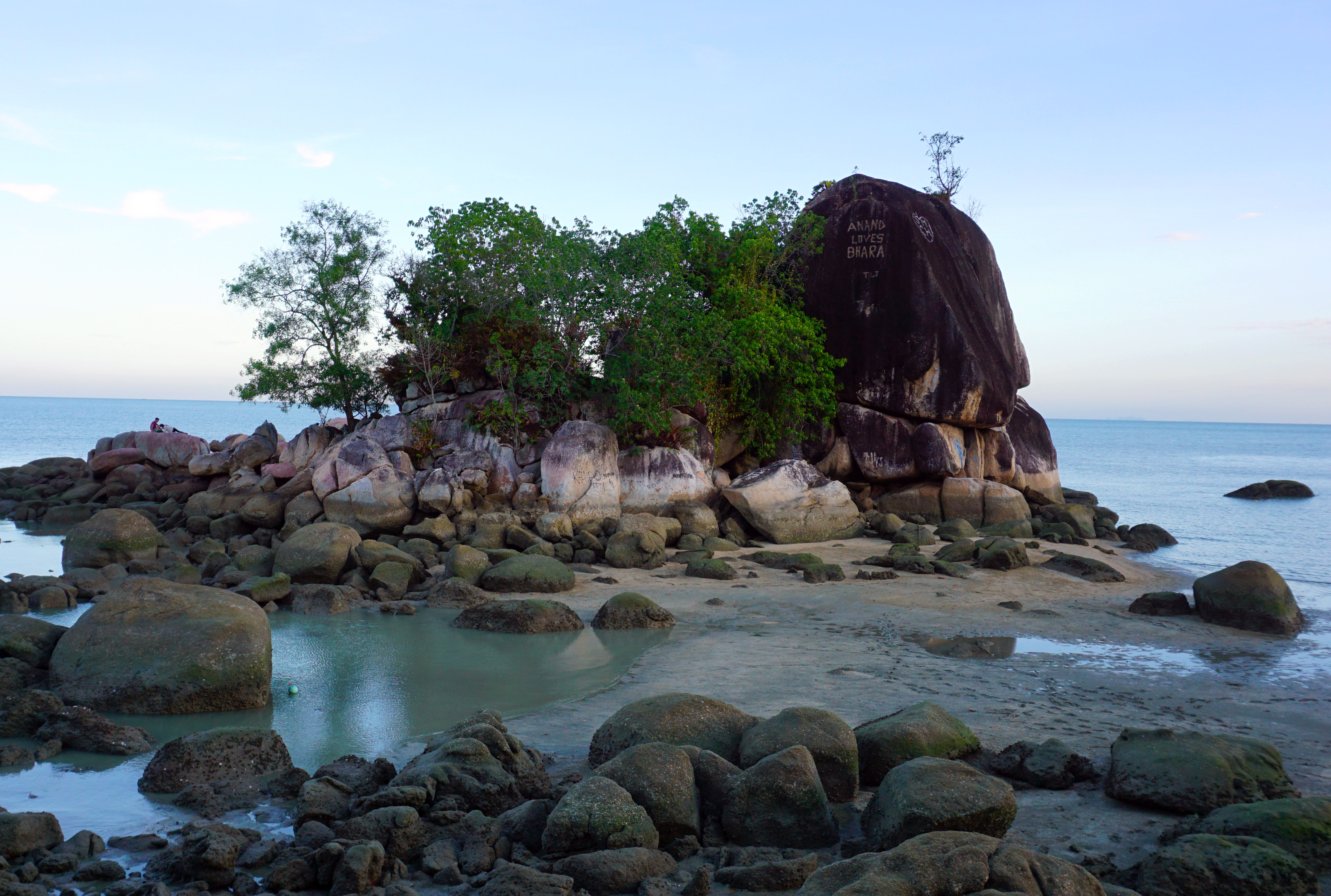
MOST VISITORS TO Penang Island would make their way to the famed Batu Ferringhi beach on its northern coast. Strolling along the golden sands, it is hard to miss the sight of a small rocky islet at the beach’s western edge. Often called Lover’s Isle by the locals, Batu Ferringhi—or Foreigner’s Rock—is the very isle that lent its name to the long stretch of coastline beside it, now one of Penang’s frequented tourist attractions.
This isle has stood out as a landmark among seafarers from ages past. Through research done by fellow Penang Monthly columnist Eugene Quah for his upcoming book titled The Illustrated Guide to the North Coast of Penang, a 1762 Portuguese navigation guide, Arte de Navegar, is found to have mentioned Batu Ferringhi Isle as a landmark to the spot on the north coast where fresh water can be obtained.
In the Peaks and Parks column, “In Search of the Legendary Isle of Batu Ferringhi” (See Penang Monthly March 2021 issue), I recounted walking along the beach right up to the rocky cape facing the islet. Sitting at that cape, I imagined how wonderful it would be to hop on one of the fishing boats moored at the nearby bay to get to the islet for a little exploration. Little did I know then that at the right time of the year, a boat isn’t even necessary to reach the isle. When Eugene told me that it was possible to walk across during low tide, I was amazed! This was something I had to see with my own eyes. It was going to be an island adventure like no other.
We turned to Tide Charts, a mobile application which provides highly accurate tidal readings, to estimate the right time to make the crossing. Our best chance would be when the low tide reading is closest to 0m. We discovered a Saturday when the tide would recede to 0.1m at around 8AM—the ideal timing for our escapade.
Our journey began at a public restroom (Tandas Awam Lover’s Isle Batu Ferringhi) nestled beneath the shade of trees near a bend in the road, just a few hundred metres past the Bayview Beach Resort. Here, we followed a narrow path downhill that wound past a few houses, quickly leading us to the edge of the Batu Ferringhi Beach. To our amazement, the waters had receded just as Tide Charts had predicted, revealing a land bridge right before us—a natural passage connecting Penang Island to the Batu Ferringhi Isle. I could hardly believe my eyes—the isle was completely above water, and appeared much larger than it did during high tide, with the adjacent large rocks, usually submerged, now fully exposed.
Scattered along the edges of the land bridge were many large rocks encrusted with cone-shaped shells. Upon closer inspection, we realised these were barnacles—marine invertebrates commonly found in intertidal zones. Though they looked “dead” when out of water, they come alive when the tides rise again. They can extend their thoracic limbs, called cirri, to sift for food.
As we ventured to the middle of the land bridge, land became muddier. With one step, “bloop”—my shoes sank into the mud. So much for the “dry” passage I had anticipated.
It took us barely two minutes to reach Batu Ferringhi Isle, where the climb began almost immediately. There was an underlying sense of urgency as low tide wouldn’t last long; in about an hour, the tide would start to rise again and cut off the isle from Penang. Interestingly, this natural phenomenon ties into the islet’s common name, Lover’s Isle. Local lore has it that lovers would cross over on foot during low tide, spend time together and, before realising, the tide would rise. They would then either be stranded on the isle until the tides recede again or have to brave the shallow waters of the submerged land bridge to get back to the main island. In fact, there are so many other stories of young lovers having escapades on the isle that, at one point, there was even a proposal to change “Lover’s Isle” to something more mundane like “Fisherman’s Isle”. Happily, this never happened.
As we searched for a way up the large, exposed rocks, we spotted what appeared to be a small passage slightly to the left, where smaller rocks formed a natural stairway. Even so, we had to use all fours to pull ourselves up! Unlike my other hikes through hills with well-signposted trails, there were none here. Instead, we had to rely on instinct and a bit of trial and error to determine which parts of the rocks were passable. After a few minutes of navigating, we reached the northern part of the islet, which offered a stunning panoramic view of Kedah’s Gunung Jerai as its backdrop.
We carefully retraced our steps back, navigating the slippery rocks while avoiding the deep holes between them. We spotted a small passage under a boulder we were passing by, leading to what appeared to be a cave-like entrance. We went through it, and it led us to a shaded area in the middle of the isle, likely the innermost point we could explore. As a few bats darted past us, we noticed how the surrounding rocks were adorned with ferns, climbing Hoyas and Epipremnum vines. The few large trees on the isle were also concentrated around this spot, including the Sea Fig (Ficus superba), a fast-growing species known for its ability to withstand highly saline conditions. Aware that the tides would soon rise, we began to search for an exit. We had two options: retrace our steps to the path we had come from or squeeze through a narrow gap between the boulders, which offered a shortcut. Opting for the latter, we got down on all fours to pass through the gap. As the passage narrowed, we had to lie down and crawl. For someone like me, who has a fear of claustrophobic spaces, it took several attempts and plenty of encouragement from my two hiking companions to summon the courage to pass through.

Emerging on the other side, we were greeted by a view of Penang Island, with the crumbling and rapidly decaying gazebo—a former viewpoint toward the isle—in the foreground. By then, a section of the land bridge in the middle had already been submerged in shallow water, signalling that it was time to head back. After snapping a few final photos, we bid farewell to Batu Ferringhi Isle. Although the walk was short and fraught with rocky obstacles, it was undeniably a memorable experience—especially since we got to walk across a land bridge during low tide, something which is a rather rare occurrence!
Hike At A Glance
Length: 1 hour
Difficulty: Moderate
Interest Level: High
Signposting: None
Likelihood of Getting Lost: Low
Number of Hikers: Few
Reference
[1] LOVER’S ISLE BY ANY OTHER NAME, The Straits Times, 18 May 1968, Page 10. Retrieved from https://eresources.nlb.gov.sg/ on 21 March 2025
Rexy Prakash Chacko
is an electronic engineer by profession and a nature lover by passion. While he spends his weekdays earning a living at the Bayan Lepas Free Industrial Zone, his weekends are spent reflecting and recharging on the green hills of Penang.