Colonial Penang’s Southern Frontier: Tin, Treaties and the Pangkor Connection
By Eugene Quah
March 2025 LEST WE FORGET
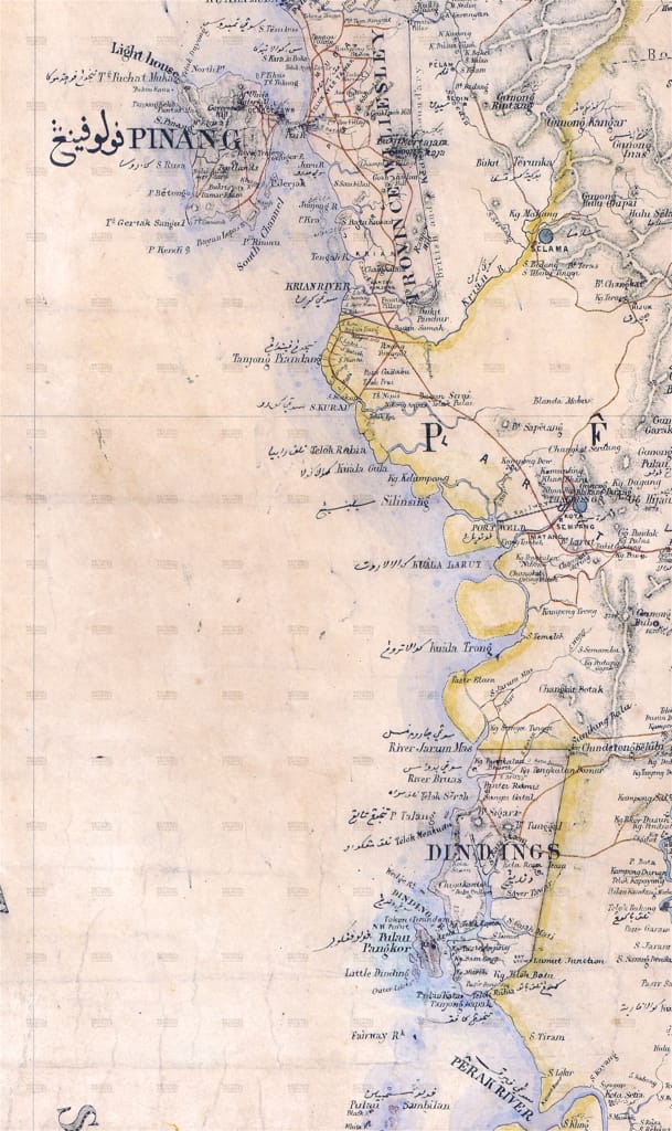
THE NAME PANGKOR was mentioned as far back as 1511 by Sulaymān al-Mahrī in his treatise al-Minhāj al-Fākhir fī ʿIlm al-Baḥr al-Zākhir (The Precious Method on the Science of the Rising Sea). He states that sailing past Falu Finanj (Pulau Pinang) towards Malaqa (Melaka), one will first encounter Dengdeng (Dinding) and then Bankūr Lau (Pangkor Laut).
The main island of Pangkor was once called Pangkor Darat (Land Pangkor), while Pangkor Laut (Sea Pangkor) is a smaller island in the southwest that, today, hosts a luxury resort. These islands act as a barrier at the mouth of the Dinding River, suggesting that “Pangkor” may have derived from the Thai “Gampāeng Koh” (pronounced gum-pang-koh) meaning “island barrier”. The Misa Melayu, an 18th-century Malay court chronicle written by Raja Chulan ibni Raja Hamid (c. 1720–1786), distinguishes between Pulau Pangkor, Selat Pangkor, Kuala Dinding and Sungai Dinding—unlike European records, which often conflate these names.
At the same time, the name “Dinding” is found in Arab navigational guides as early as 1426, and may relate to the Thai “Din Daeng”, meaning red earth—a name still used by local Malays, who refer to Lumut as “Tanah Merah” (red earth) and local Chinese, who use the Hokkien term, “Ang Thor K’um” (red earth cover).
The strategic importance of Pangkor was recognised early by European powers. On 29 November 1663, the Dutch navigator Wouter Schouten stopped at Pangkor to obtain fresh water, and he wrote:
“The Island Dinding [Pangkor]... is uninhabited, full of Mountains, vast Forest and very dreadful Wilderness... It is said on this Island... the best fresh water of the whole of East Indies is found.”
The Dutch East India Company (VOC) took possession of Pangkor in 1670. According to a later report by Balthasar Bort, the Governor of Melaka, by 1678 “59 men are before Pera, engaged in the blockade of that place and stationed on the island of Dingdingh [Pangkor]... occupying a square wooden fort there provided with [nine] pieces of iron ordnance.”
This outpost was abandoned after it was sacked by Panglima Kulup in 1690. In 1743, a stone fort was built to house a garrison of “30 Europeans and the same number of native soldiers”. This fort was only used for five years and then left to ruin. The reconstructed ruins of this second fort still stand today.
At the south-eastern end of Pangkor at Teluk Raja Bayang (Bay of the Shadow King) is a Malay fishing village marked by a handsome mosque. Local lore identifies this as the site of the first Malay settlement.
The mysterious Raja Bayang, despite local supernatural tales, appears to have been a Perak merchant. A letter from the Sultan of Perak to Francis Light dated 26 October 1787 mentions him:
“... if Raja Bayang and Raja Lela Sutan... face any difficulties or illnesses, our friend should assist with the remaining expenses and all transactions... Our friend, the Governor, is our only hope in Penang Island... we have nothing else to say except for three pieces of tin as a token of our hope...”

The Larut Wars and Their Aftermath
The Malay kingdom of Perak—the Abode of Grace (Darul Ridzuan)—was a country in turmoil in the 1870s. The mineral-rich land had suffered years of unrest. Chinese secret societies were at war with each other. What began as a dispute over mining and water rights between two factions escalated into a series of violent conflicts which became known as the Larut Wars. The two main factions, or hoay, were the Hai San and Ghee Hin, led by Chung Keng Kwee and Chin Seng Yam, respectively.
In 1850, Che’ Long Jaffar, a son of a minor Perak chief, having obtained a title to the Larut district, started his first mine at Klian[1] Pauh and invited others to work the land. The “rich tin-fields became known, and more Chinese flocked to the area”. By the 1860s, most tin mines in Perak were principally funded by Penang towkays. Later, his son and successor, Ngah Ibrahim, obtained a new deed from the Sultan and ruled with greater authority than his father as the Mantri (Menteri) of Larut.
The conflict between the two Chinese factions escalated when the Mantri supported the Hai San, eventually spilling out of Perak. In one instance, the Ghee Hin even burned the Mantri’s house in Penang, near what is now Muntri Street. Penang’s closeness to Perak made it more influential than Singapore over the tin trade.
In 1874, Andrew Clarke, the new governor of the Straits Settlements, found the tin trade severely disrupted by strife, and sought a political solution. When an opportunity rose to install a compliant Perak prince amenable to British advice to the throne, Clarke quickly summoned all the parties involved for talks to set his plan into action. This engagement would signal the start of direct British intervention in affairs of the Malay states—something the Colonial Office had tried to avoid doing.

The Pangkor Treaty
Frank Swettenham, one of the officials tasked with organising the talks, recounted in his journal:
“I went from Pinang to Larut on board HMS Avon to tell the Chinese that their friends in Pinang had agreed to suspend hostilities, and to invite the Mantri, and any other chiefs who could be got at, to meet Sir Andrew at the rendezvous on 15 January [1874] ... at Pangkor.”
Swettenham noted that those present were:
“Raja Abdullah [the claimant], his relative Raja Idris (the present Sultan of Perak), and the chiefs... also the Raja Bendahara, the Mantri, the Temenggong and the Dato Sagor [uncle of the Mantri]... Mr. Pickering and the heads of the Chinese factions were also present.”
At the Perak Museum in Taiping—the oldest in the country—there is an exhibit depicting a Malay royal and a high-ranking British official seated at a small, sturdy wooden round table aboard the colonial steamer HMCS (Her Majesty’s Colonial Ship) Pluto. The scene represents that fateful Tuesday afternoon in January 1874, when Raja Muda Abdullah, claimant to the throne of Perak, and Governor Andrew Clarke of the Straits Settlements signed a document that forever altered the political landscape of the Malay peninsula. After the signing of the treaty, hostilities between the Chinese secret societies ceased. The British then established a new planned town near Klian Pauh named Taiping, meaning Eternal Peace.

Tale of a Tragic Table
The physical witness to this momentous treaty was a wooden table that would later become a remarkable colonial Malayan artefact. Its history emerged when Hubert Berkeley, then District Officer of Upper Perak, donated it to the Taiping Museum. In his accompanying documentation, Berkeley wrote:
“The history of this table was given me by Tukang Ismail [Craftsman Ismail], who made it, and by Penghulu [Village Headman] Haji Mat Akib, who had it made for the house he built in January, 1874, for the Pangkor Treaty.”
According to Edward Marsh Merewether, a few years prior to the Pangkor Treaty, a “Kedah Malay named Haji Mahomad Akib[2] conceived the idea of settling at Pangkor, and applied to the [Lieutenant-Governor] of Penang [Col. Henry Stuart Man] for permission to do so”. The seemingly innocuous request turned out to be anything but, for the authorities were “doubtful whether it was British Territory”. It led to a most curious discovery, according to Peter Benson Maxwell, former Chief Justice of the Straits Settlements:
“... in 1866 the old Malay paper [a treaty] was found in a pigeon-hole [filing cabinet] in the Government office [in Penang]; and our officers, ignorant of its history, claimed the long-neglected gift”—Pulau Pangkor.
Satisfied that Pangkor was indeed British territory, the Penang authorities gave Mat Akib permission to settle at Pangkor together with “a concession 100 orlongs of land”. In early 1867, Col. Archibald Anson noted that Pangkor had “recently been occupied by three Malays, to whom permit to occupy and clear land... had been given, and a small population, many of whom were escaped slaves from Perak, has sprung up there”. According to Merewether, who knew Mat Akib personally:
“He induced a few others to join him, but most of them went away... as Pangkor and Pulo Sem - bilan... were in those days the favourite haunt of pirates... [and] for the first few years Mahomed Akib lived almost alone.”
After the signing of the treaty, the table stood inside the house and was passed on to its various ill-fated British occupants. In 1878, Captain Lloyd, one of the later owners of the table, was brutally murdered by a Chinese gang while at home. His assailants then attempted to burn down the house to cover up the crime, but Penghulu Akib arrived in time to put out the fire.
The table eventually passed on to the Superintendent of Dindings, R.R. Bruce, who, when seated at this table one morning, was stabbed from behind with a golok by a Malay who had run amok. When the gravely injured inspector returned home in 1883, “he gave this table and all his things to his Siamese woman [mistress], who sold me the table,” recounted Berkeley. The table is now kept at Muzium Negara, while the one in the Taiping Museum is a replica.

Colonial Administration and Modern Legacy
The Pangkor Treaty of 1874 formalised British control over not just the island, but also a strip of mainland that became known as the Dindings. This interpretation stemmed from an earlier 1826 treaty which, according to Maxwell, who cited the now-lost original treaty written in Malay, only ceded the islands: “Pulo Dinding-Pangkor, dan sakalian pulo pulo sablah laut”—the island of Dinding-Pangkor, and all the islands to the seaward.
However, the English translation of the treaty read:
“The Sultan... ceded to the Honourable East India Company... henceforward and for ever, the Pulo Dinding and the Islands of Pangkor, together with all and every one of the Islands.”
Based on this awkwardly worded English translation, the Straits Settlements government under Henry Ord “revived the claim, and presented it in a new and expanded form. The plain opposite the island, and a range of hills beyond, were now said to be included in the cession”. Andrew Clarke, concurring with his predecessor’s interpretation, incorporated this spurious claim to the mainland strip into the 1874 Pangkor Treaty. Upon the treaty’s ratification, the expanded territory became part of the Straits Settlements—as administrative dependency of Penang—known as the Dindings. It was only on 17 February 1935 that the Dindings, together with Pangkor, were finally ceded back to Perak. In 1973, the Daerah Dindings [Dindings District] and its eponymous river was renamed Manjung.
Today, Pangkor’s historical connection to Penang lives on through its Chinese fishing community, who still speak Penang Hokkien—a linguistic legacy of the island’s 109-year association with its northern neighbour. And in Penang, this shared colonial past is preserved in the name of two streets—Jalan Dinding and Jalan Pangkor.


References
[1] Archibald Edward Harboed Anson (1920), “About Others and Myself 1745 To 1920”
[2] Balthasar Bort (1678), “Report on Malacca”, M.J. Bremner (Translator), Charles Otto Blagden (Editor).
[3] Barbara June Watson Andaya (1975), “Perak, The Abode of Grace - A Study of an Eighteenth Century
[4] C.D. Cowan (1950), “Governor Bannerman and the Penang Tin Scheme. 1818-1819”, JMBRAS, Vol. 23, No. 1 (151) (February 1950), pp. 52-83
[5] C.S. Wong (1964), “A Gallery of Chinese Kapitans”
[6] D. MacIntyre (1961), “Britain’s Intervention in Malaya: The Origin of Lord Kimberley’s Instructions to Sir Andrew Clarke in 1873”, Journal of Southeast Asian History, Vol. 2, No. 3 (Oct. 1961), pp. 47-69
[7] Edward Marsh Merewether (1891), JSBRAS, No. 23, “Outline of the History of the Dindings”, pg. 35-47
[8] Frank Athelstane Swettenham (1875), “Sir Frank Swettenham’s Malayan journals, 1874-1876”
[9] John Anderson (1824), “Political and Commercial Considerations Relative to the Malayan Peninsula and the British Settlements in the Straits of Malacca Peninsula”, pg. 178-170
[10] K. E. Chan, C. H. Cho, S. H. Khoo (1971), “Journal of Southeast Asian Studies, Vol. 2, No. 2 (Sep. 1971), “Place-Names in the Sitiawan Area, Perak”, pg. 185-194
[11] Khoo Teng Tiong (1999), Warta Geologi, Volume 25, No. 3 May-Jun 1999, “Coastal geomorphology of the Strait of Malacca area during the past millennium”, pg 161-164
[12] Malay State”, Thesis.
[13] Paul Wheatley (1961), “The Golden Khersonese: studies in the historical geography of the Malay Peninsula before A.D. 1500”
[14] Peeravit Koad Thatdao Rakmak (2023), “The Role of Astronomy in Determining the Locations of Geographical Features During the Eleventh to Seventeenth Centuries”.
[15] Peter Benson Maxwell (1878), “Our Malay Conquests”
[16] Raja Chulan ibni Raja Hamid (2015), “Hikayat Misa Melayu”, Eds. Jelani Harun, Zainal Abidin Borhan. Based on (MS Or. 832)
[17] Sultan Ahmaddin Shah ibni Sultan Muhamad Shah (1787), “Surat Sultan Perak kepada Francis Light berkaitan pembelian beras”, Letter dated 26 October 1787, MS 40320/11, f.33
[18] Wilkinson, R.J. (1908), “Papers on Malay Subjects: History (Part II) Notes on Perak History, pg. 89-90.
[19] William Dampier (1729), “A Collection of Voyages: In Four Volumes: Containing I. Captain William Dampier’s Voyages Round the World”, pg. 171-176
Footnotes
[1] Contraction of kelian, an old word for a surface mine. Related to the modern word galian (mineral).
[2] Not to be mistaken for Penghulu Mat Akib of Bandar Bahru—an enemy of Dato’ Sagor, the Mantri of Larut’s uncle.
Eugene Quah
is an independent researcher and writer who is working on a book tentatively called “Illustrated Guide to the North Coast of Penang”. He rediscovered the joys of writing after moving back to Penang from abroad.